Get Social
If you like this page, why not share it?
Currency Converter
You can check what your currency is worth in Euros by using our currency converter.
Hiking & Walking in Nerja
Nerja is fortunate to have not one but two Natural Parks right on its doorstep offering inland mountain hikes as well as coastal walks just a stone’s throw from the town. The rugged hills of the Sierras of Tejeda, Almijara and Alhama generally offer walks for more physically capable walkers with many of the paths leading to mountain passes and steep climbs. The Acantilados de Maro-Cerro Gordo Natural Park is primarily a coastal park with untouched beaches and plunging cliffs although its generally flatter nature means that there are less physically demanding walks allowing less capable visitors to still enjoy the natural beauty of the area. With this in mind we’ve documented a couple of walks, one in each park, which while not tremendously demanding should give you a taste of what they offer whilst providing some beautiful views along the way. If you’d like to discover more hiking routes with information on local flora and fauna thrown in check out Jim Ryan’s excellent book, The Mountains of Nerja.
(Please be sensible when undertaking these walks. Let people know where you’re going and when you expect to be back. Make sure you have sturdy footwear and sufficient food, water and sunscreen.)
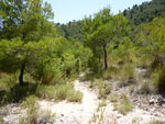
Nerja Caves – El Pinarillo – Nerja Caves
This is a great introductory walk to the Natural Park of the Sierras of Tejeda, Almijara and Alhama. It will take 4 – 5 hours depending on your ability, leading you in a circle along well used paths with a little bit of adventure in the final half as you walk along an ‘arroyo’ or dry riverbed. Obviously don’t attempt this walk after periods of prolonged rain. As you walk you’ll see plenty of other tracks that lead off deeper into the natural park giving you some areas to explore in future visits. Despite being a moderately easy walk it’s still advisable to wear good sturdy walking shoes, sandals are not recommended!
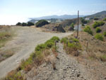
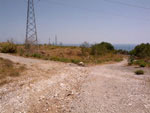
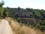
Make your way to the Nerja Caves and park your car to the left of the entrance to the Caves parking area where you’ll likely find some shade from the trees. From here head up the slope where you’ll find a track wide enough for cars and a large Natural Park sign.
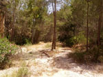
This track will take you to the picnic area ‘El Pinarillo’ and will make up just under half of the walk (at least in distance). The track takes you gently uphill for about 50 mins when you’ll come to a split in the path. Take the left hand fork, the right will take you on the path to the peak of El Cielo.
After 20 – 30 minutes more of walking you’ll reach the picnic area. Once again there is a fork at the entrance, take the path on the left and follow it. As it curves to the right and downwards you’re led to the dry riverbed which will make up part of the walk later on. Cross it and continue up the steepish climb on the other side until you come to the first established path on the left. This track is very well used and will lead you to the other side of the valley you’ve already been walking through. On clear days you’ll get some great views of some of the peaks from here and you’ll also start your descent on this track.
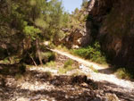
Follow this track until a point where it seems to end rather abruptly. This is where the slightly more adventurous section begins. The track hasn’t really ended but it’s now far narrower and leads through the trees to a steep and slightly loose underfoot descent. This descent is very short, about twenty meters and leads into a tributary of the dry river you crossed earlier.
The area you arrive in is quite shady and rocky with the path carved out by the water between the rocks so follow the path the water has taken downhill. As you walk you’ll come to a number of small waterfalls. To begin with these can be a little daunting but there are plenty of good footholds and as they’re not very high they should pose no problem for most walkers. After 30-35 minutes walking this dry stream will filter into the main riverbed which is far wider.
Continue following the rivers path downhill through the trees. After a while you’ll come to an area with far denser vegetation. There is a small dam ahead which pools water during very wet periods (although I’ve never seen water here). As you move through the vegetation try to keep a little to the right and look for a small and slightly overgrown path that leads around a large rock. From here you can pass over the dam wall and down a path on the other side. This is a little precarious although again, no problem for most hikers.
After another Kilometer or two you come to another split in the path, one that continues slightly downwards through the trees and another one that leads up a path on the hillside ahead. Take the path on the right that leads upwards to a far more open area where you’ll probably recognize the tack you started the walk with on the other side of the gorge.
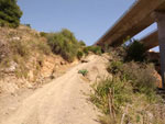
Unfortunately this isn’t a very picturesque area but continue downhill until you reach an electricity pylon where you need to go right. You’ll find yourself next to the motorway with a small tarmac access road in front of you. Go left along the access road and through a large tunnel that runs underneath the motorway. Upon exiting go left and back onto a dirt track.
You’ll now come to a goat herders hut and no doubt receive a noisy welcome from his dogs. They’re loud but friendly so carry on past to the edge of the gorge that you left earlier. There is a path here that leads below the large motorway bridges and up to the other side. Follow this path which will take you back to the road that leads to the Nerja Caves entrance. Once here just follow the road upwards to where you left your car.
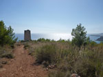
Maro Tower
This is a nice, simple little walk, just under 2km long, that should take about an hour and lead you to some areas with stunning views over Nerja, Maro beach and the coast of the Alcantilados de Maro – Cerro Gordo natural park. It’s suitable for all ages and abilities but be advised that there is very little shade from the sun on this circular walk and if you follow the direction we’ve described here you will encounter a short but steep ascent.
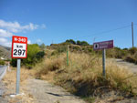
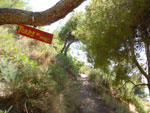
To start this walk you need to leave Nerja and head towards Maro. Go through the village and continue on the N340 coastal road in the direction of La Herradura. Not long after leaving Maro you need to start looking to the right for a track at km 297 with a small sign for ‘Torre de Maro’. Pull off the road here where you’ll find plenty of space to park your car. (Note: you can also get the bus to Maro and walk to the starting place, it’s not far and won’t take too long)
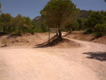
You’ll now find yourself in an open area with a track in front of you leading upwards, follow this track and you’ll find yourself at another open area suitable for parking cars. You’ll see that the track splits in front of you, one heading upwards and one downwards. We’re heading downwards however the track to the left heading upwards is the return route so if you wish to do this walk in reverse then you can take the left.
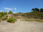
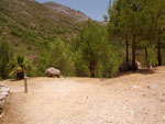
You’ll now be walking downhill with the track you’re following clearly visible to you as it bends right following the contours of the hill. You’ll also start seeing some of the fabulous views here with Nerja visible in the distance. Follow this track until you find yourself at a third flat, open area.
From here start to look for a track to the left which will lead you up to the top of the hill where the Maro tower is located. There is a small sign hanging from a tree. This is the beginning of a steep section with the worst parts made up of steps. Keep going and you’ll be rewarded with some beautiful views at the top!
You’ll emerge from this uphill section and come straight to the side of the restored Maro watchtower. After the uphill climb take a rest here, you’ve earned it.
You’ll notice behind the watchtower a well walked track heading roughly northwards, this is the track which you need to take to return to the parking area. Just follow it back, there are no off-shoots and you’ll find yourself descending the stepish slope you saw when you first started out and your car ahead of you.